
Stories
Maps Are Political, Not Neutral: UN Resolution Challenges Distorted Worldview
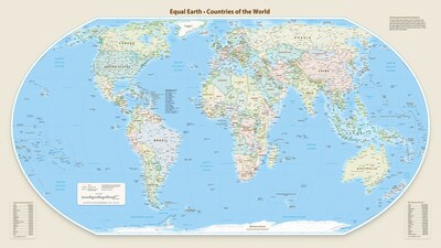
- •A UN General Assembly resolution, 'Correct the Map,' endorsed by 164 countries, advocates for equal-area map projections to accurately represent country sizes.
- •The United States was the sole country to vote against the resolution, with its objection framed as political rather than cartographic.
- •The Mercator projection, originally a sailor's tool from 1569, dramatically distorts landmasses, making areas near the poles appear much larger than they are, and became the default world map in classrooms.
- •Critics argue that the continued use of distorted maps like Mercator shapes perceptions of global importance, trade, and investment, often minimizing the true scale of regions like Africa and South Asia.
- •The resolution, initiated by Togo and the African Group, highlights how maps are texts produced within power relations, and challenges the colonial-era assumption of a neutral world order.
Key Questions Answered
The UN General Assembly's 'Correct the Map' resolution, tabled by Togo on behalf of the African Group, encourages governments, schools, international organizations, and technology companies to prefer equal-area map projections like Equal Earth. It aims to accurately represent the relative size of countries and teach that no flat map can represent a sphere without distortion, addressing the inaccuracies of the Mercator projection.
The United States was the sole country to vote against the 'Correct the Map' resolution, with its objection being political rather than cartographic. The resolution's proponents suggest that the US response, framing the vote as a matter of UN credibility, reveals resistance to change and a defense of the status quo, which is also ideological.
The Mercator projection, created in 1569, distorts the relative size of landmasses, making areas near the poles appear much larger than they are, while regions near the equator appear smaller. For example, Greenland appears roughly the size of Africa, despite Africa being more than 14 times larger. While geographers and publishers moved away from it decades ago, it remains in use for nautical charts due to its utility for navigation, and it gained a second life in digital mapping services like Google Maps for convenience.