
Stories
India Builds 'Land Stack': Digital Trail for Every Land Parcel Revolutionizes Records
- •India's Department of Land Resources has nearly completed the digitization of basic land records, with 99.9% of Records of Rights (RoRs) computerized.
- •The Modi government's ambitious 'Bharat Land Stack' aims to create a digital architecture for each land parcel, linking diverse information across government departments.
- •Unique Land Parcel Identification Numbers (ULPINs), or Bhu-Aadhaar, have been generated for 39.43 crore of 58.76 crore land parcels, forming a common identifier.
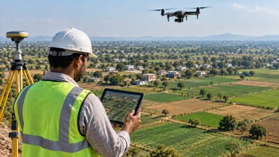
- •The Land Stack integrates drone/satellite imagery, cadastral maps, RoRs, registration data, master plans, building plans, and restrictions for comprehensive property information.
- •DILRMP 3.0, with a Rs 565.50 crore outlay, focuses on interoperability, connecting various land record components to support property taxation, utilities, and dispute resolution.
Key Questions Answered
The Unique Land Parcel Identification Number (ULPIN), also known as Bhu-Aadhaar, is a digital identity for land parcels. Out of 58.76 crore land parcels, ULPINs have been generated for 39.43 crore parcels, which is about 67.11%.
Launched on September 10, 2026, DILRMP 3.0 operates with an outlay of Rs 565.50 crore for the 2026–31 period to transition land records from simple digitisation toward full interoperability. It builds the Bharat Land Stack, integrating drone and satellite imagery, cadastral maps, Records of Rights, registration data, master plans, and litigation layers into one connected ecosystem.
Government datasets reveal that approximately 99.9% of Records of Rights (RoRs) have been computerised, accounting for about 39.99 crore out of 40 crore RoRs. Additionally, roughly 97.43% of cadastral maps have been digitised, while the integration of cadastral maps with RoRs stands at 84.59%.