
Stories
Himalayas on Edge: Landslides Threaten Towns Amidst Changing Climate and Human Activity
F
Firstpost•30-09-2026, 12:46
Himalayas on Edge: Landslides Threaten Towns Amidst Changing Climate and Human Activity
- •The Himalayas are increasingly vulnerable to landslides due to a combination of geology, terrain, rainfall, and human activities, as highlighted in the "Hills on the Edge" series.
- •Joshimath serves as a stark example, where residents were forced to evacuate due to ground sinking and deformation, attributed to the town being built on an old landslide deposit.
- •Landslide susceptibility is not uniform across the Indian Himalaya, with Arunachal Pradesh, Sikkim, Uttarakhand, and Himachal Pradesh showing particularly high vulnerability, especially in the north-western region.
- •Climate change is altering the character of Himalayan landslides, with extreme rainfall, changing temperatures, glacier retreat, and permafrost degradation interacting to increase landslide activity, particularly at higher elevations.
- •Human activities like road construction, deforestation, and unintegrated development practices significantly exacerbate slope instability, emphasizing the need for development that respects the mountain's natural behavior.
Key Questions Answered
A 2025 national assessment revealed that very high landslide susceptibility zones cover 52.1 percent of Arunachal Pradesh, 45 percent of Sikkim, 40 percent of Uttarakhand, 28.9 percent of Himachal Pradesh, and 20.2 percent of Jammu and Kashmir.
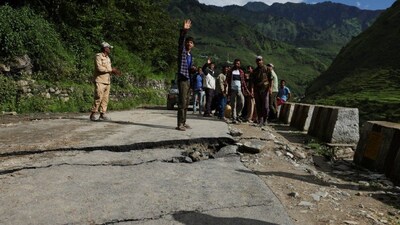
A 2024 study on a 247-kilometer section of NH-7 recorded 309 road-blocking landslides following heavy rainfall, finding that road widening was associated with a doubling of such incidents due to changes in stress distribution and drainage.
India has established the National Landslide Forecasting Centre to coordinate early-warning systems, launched a Rs 1,000-crore mitigation project across 15 states, and utilizes ISRO’s Landslide Atlas alongside satellite radar data to track ground deformation.